Sunday, May 4, 2014

Ecuadorian Officials Use GPS Tracking to Help Thwart Drug Trafficking

The State of Things


Have you ever heard of the Urabeños, the Rastrojos, or La Cordillera? How about the Sinola Cartel? Perhaps you’re unfamiliar with these groups, but they have all been linked to the trafficking of illegal drugs in Ecuador. In fact, experts say that Ecuador’s role as a leader in the sale and transport of illegal drugs is on the rise. That’s a role that the country’s leadership would like to diminish and ultimately abandon. But how? Ecuadorian leaders say GPS technology can play an important role.


SatelliteA Nationwide System


In December 2013, Ecuador launched a nationwide system to track the movement of controlled substances in their country through the use of GPS tracking. The ultimate goal is to dramatically cut down on the flow of such substances into the hands of those who create and distribute illegal drugs and those who create weapons of destruction (i.e., bombs) in the country and throughout the world.


This system is not designed to monitor the flow of illegal drugs themselves; instead it’s intended to monitor the flow of legitimate chemicals that may be misused to produce illegal drugs, such as cocaine, and as ingredients in homemade explosive devices. Such substances include sulfuric acid and hydrochloric acid and can be expanded to include potassium permanganate, calcium chloride, hexane, toluene, and acetone.


How Does the System Work?


It all starts from the point of arrival for the substance—whether that’s an airport, shipping dock, or other location. Vehicles that transport the materials for private companies are equipped with sensitive GPS-enabled monitors. If a vehicle departs from its prescribed route or if its cargo doors are opened at an unauthorized time or in an unauthorized location, authorities are immediately notified. In addition, each vehicle includes a “panic button” that a driver can activate if, for example, someone tries to waylay him or highjack his shipment. If the GPS tracking system is triggered, authorities can respond within minutes to ascertain what the problem is.


This system is the only reasonable, accurate, and immediate way to keep track of hundreds of shipments being conveyed every day by the over 200 companies permitted to transfer such materials. In Ecuador as a whole, over 1,800 companies are permitted to sell such materials.


Who is Putting This Program Together?


Ecuador’s National Council for the Control of Narcotic and Psychotropic Substances (abbreviated “CONSEP”) is the governmental agency behind the creation and implementation of this National Georeferencing System. It’s their responsibility to grant licenses to companies and to ensure that dangerous but legal substances (such as calcium chloride, toluene, and so on) are safely stored and transferred. The implementation of GPS tracking technology has made doing so much easier, increasing drivers’ safety and accountability.


CONSEP was established in the early 1990s as an outgrowth of the Narcotic and Psychotropic Substances Act. Regulations based on the act mandated the establishment of CONSEP with the purpose of “combating and eradicating the production, supply and abuse of narcotic and psychotropic substances and the illicit traffic in them.” It also provided CONSEP with the oversight of those permitted to make and sell “controlled substances” and allowed CONSEP to work with recovering addicts and in the prevention of drug abuse. CONSEP’s mission statement, somewhat loosely translated into English, instructs the group to “generate and monitor participatory processes for drug prevention, with a focus on the subject and a healthy approach to living.” Their vision statement, also rather loosely translated, directs them to “lead a culture of drug prevention with a committed, responsible, and capable team.”


It is interesting that, according to some sources, Ecuador’s drug war is not aimed at eradicating illicit drug use from the populace. In fact, according to the country’s Constitution, the use of illicit drugs is viewed as a health concern rather than a crime. Even more interesting is that CONSEP has set what they consider to be reasonable “maximum amounts” of drugs that would be considered illegal in many other nations. For example, they recommend that citizens of Ecuador be permitted to possess small amounts of marijuana, opiates, cocaine—and even meth, LSD, and heroin.


The Program’s Reception


Leaders of the GPS monitoring program think private companies—who stand to lose profits if their shipments of so-called “precursor chemicals” are stolen—will be grateful for the program. In February of 2014 Ecuador’s Armed Forces Joint Command, in tandem with the country’s Arms Control Department, began requiring companies that legally provide certain levels of these chemicals (more than 200 metric tons) annually to appear on a registry list.


The program has received kudos from as lofty a group as the United Nations International Narcotics Control Board, and Ecuador is working with other countries in Latin America that want to implement such a program in their nations—including Venezuela, Costa Rica, Chile, Argentina, Bolivia, and Uruguay.


Ecuadorian Officials Use GPS Tracking to Help Thwart Drug Trafficking

Saturday, May 3, 2014

Earth-Shaking News About GPS

Who can ever forget the devastating earthquake and tsunami that rocked Japan in 2011? So many lives were lost and so much destruction caused. And then the questions: What could have been done to lessen the impact? How could more lives have been saved? Technology may hold the answers. Scientists are looking to GPS technology to give them early warning signs for many types of natural disasters, including the notoriously unpredictable earthquake. By combining the precision of GPS with existing technologies used to monitor the earth’s motion, experts may soon be able to warn residents of threatened areas to take cover in time to save many lives.


earthfromspaceThe Power of Prediction


In the past, earthquakes just seemed to happen without any warning. Today, scientists use a network of seismometers in earthquake-prone areas to pinpoint the center and intensity of an earthquake. Seismometers measure ground motions, including the seismic waves produced by earthquakes and volcanoes. Scientists believe that adding GPS tracking devices to the equation can get them even earlier and more accurate data, thus giving authorities more warning time. The large waves of an earthquake move relatively slowly, so knowing its precise center and intensity within seconds could mean the difference between life and death. How might these statistics have been different if people had been warned earlier?


  • October 2013—32 people killed in 7.1 earthquake in the Phillipines

  • September 2013—900 people killed in 7.7 earthquake in Pakistan

  • July 2013—95 people killed in 5.9 earthquake in China

  • April 2013—160 people killed in 6.6 earthquake in China.

  • April 2013—37 people killed in 6.3 earthquake in Iran

  • February 2013—18 people killed in 8.0 earthquake in the Santa Cruz Islands

These statistics cover only major earthquakes that took place last year and don’t begin to mention the thousands wounded or the extensive damage done. While preventing earthquakes is clearly outside human possibility, early warning systems could get people to safer areas and out of vulnerable buildings before they strike.


Initial Tests


Scientists are currently testing a system that takes existing GPS stations using GPS receivers to see if adding accelerometers will improve their ability to predict an earthquake. The accelerometer can sense even the smallest, most subtle movements in the earth’s crust, especially primary waves that predict the secondary waves that cause the violent shaking of a quake. In combination with the GPS data, scientists can pinpoint an earthquake’s location to within a few centimeters. Authorities can then alert people to take cover, turn off gas lines, stop their cars, and a multitude of other last-second precautions that can be taken to save lives.


A Successful Forecast


Researchers at the Georgia Institute of Technology were able to successfully predict the Nicoya earthquake that took place in Costa Rica in 2012. The Nicoya Peninsula sits on a subduction zone that results in a large-scale earthquake about every 50 years, so scientists have been gathering data in this area for many years. Most recently, beginning in the 1990s, they have employed GPS technology to map the area’s stored energy. “This is the first place where we’ve been able to map out the likely extent of an earthquake rupture along the subduction megathrust beforehand,” said Andrew Newman, an associate professor in the School of Earth and Atmospheric Sciences. With the data in hand, the researchers predicted that the area was due for a 7.8 scale earthquake. They could not determine a set time frame, but they knew it was coming and that it was going to be big. In fact, the earthquake hit just a few months later and measured 7.6 on the Richter scale, proving the validity of GPS technology.


The Possibility of Prediction


Forecasters have long decried their inability to get earthquake warnings out in a timely, life-saving manner. Although data gives them an idea of changes in the earth’s crust that could lead to an earthquake, the true force of the disaster is usually known only seconds before it occurs. Now, through the work of Professor Kosuke Heki at the Hokkaido University in Japan, scientists may well be on their way to making huge advancements in earthquake prediction, not just forecasting. Professor Heki studies and analyzes GPS signals by measuring the Total Electron Content (TEC) in the upper atmosphere. While looking at TEC disruptions after the 2011 earthquake in Japan, he quite accidentally discovered disruptions in the TEC about 40 minutes before the earthquake hit.


Professor Heki’s work with GPS and TEC is being acclaimed by scientists around the world as a breakthrough in earthquake prediction. With the ability to anticipate a natural disaster as devastating as an earthquake well in advance of its onset, authorities may be able to more effectively get people out of harm’s way and save lives.


Earth-Shaking News About GPS

Friday, May 2, 2014

A Better Way to Farm

Farming has always been a tedious, time consuming, back-breaking way to earn a living. The farmers of our country have always held a high place of respect and awe from the rest of us pencil pushers who take advantage of the sweat of their brow to make sure that we have enough food on our table. Farming has always been a balance between learned skill and guessing game with regards to the weather and nature, and how to best irrigate and fertilize your crops to make sure you have the best yield possible to keep you in business for the long run. Today’s advances in technology is also doing great things to help with farmers. A recent development by Trimble matches the benefits of GPS technology with good old fashion farming to make sure crops are taken care of.


farm-equipment-tractorHow it Works


The Trimble Irrigate-IQ works with farmers’ irrigation system to remotely control irrigation and fertilization systems using GPS technology to make sure that crops maintain the optimal level of hydration and fertilization. Among the benefits of this system is a way to ensure that the crops receive just the right amount, which will help produce a better crop each season. There are cost savings galore thanks to the GPS technology involved with this product. A farmer would be able to save electricity and gas from operating the system only when it was needed. The environment would be helped by having less runoff of chemicals and fertilizer. There is also the added benefit of being flexible to handle a variety of solutions from several different companies.


Mobile or Desktop Enabled


The use of GPS technology also allows this product to be paired with an app that is compatible with iPhone, iPad, and Android operating systems. By using the GPS technology, farmers will be able to check on the progress of each pivot for irrigation to make sure they are functioning at optimal levels. They will be able to remotely control the operation of the pivots, while also being able to switch to different levels of fertilizer or water. In addition to the work that can be done using mobile technology, there are also software programs to do the same from traditional desktop and laptop computers. Farmers will be able to acquire the app for free, which will give them greater freedom to manage their irrigation from anywhere.


Balance of International Trade for Agriculture


YearResult
2005Exported approximately $4,000,000,000 more than we imported
2006Exported approximately $5,500,000,000 more than we imported
2007Exported approximately $17,000,000,000 more than we imported
2008Exported approximately $34,800,000,000 more than we imported

Narrowing the Farming Gaps


The ability of farmers to use GPS technology allows them to expand everything from the size of their farms to the variety of their crops. With devices like the Irrigate-IQ and others like it, much of the sheer labor is being removed from the profession of farming. As the prices on these devices comes down, it will also allow smaller sized farms to achieve the same kinds of efficiencies that larger farms have enjoyed for years. Using the GPS technology allows for farmers to take more of the guess work out of farming. They still won’t be able to predict the weather accurately (but really, who can?), but the use of this technology will only help to reduce barriers to larger yields.


Virtual Farming


While there will still be a lot of blood, sweat, and tears with farming, the use of GPS technology, satellites, machinery, robots, and so forth is making farming more of a thinking man’s (or woman’s) game. While there is still the need for a lot of brute force and hard labor, the way technology is improving is putting more of an emphasis on working smarter at what you are trying to accomplish. The yield of most fruits and vegetables is growing in leaps and bounds. While the United States continues to import more manufactured goods than we export, we also continue to export more agricultural goods than we import. We have become the breadbasket of the world and with each new advance in technology, our bread basket will only keep giving and giving. Perhaps the amazing part about our increased production is that we are doing it with less land. The amount of land used in farming for pastures or crops has decreased slightly over the past 50 years while we are doing more with the land.


Our nation’s farmers are something to be proud of. The tireless and thankless work they do every day is something to be admired. Using GPS technology for something that is so much more important than finding a faster way to the mall is worth to provide food for so many.


A Better Way to Farm

Tuesday, April 29, 2014

Taxi Driver Unlawfully Uses GPS Jammer to Increase Fares

Australian authorities continue their search for a taxi driver who used an unlawful GPS jamming device to increase his fares. Australian Communications and Media Authority (ACMA) employee Chris Fosten confirmed that the ACMA’s attempts to contact the taxi driver have been met with failure. The cabbie is believed to have fled to India to avoid his upcoming trial.


taxiThere are several reasons to penalize GPS jamming. Since he wasn’t near the customer’s location, this cabbie was stealing work from his fellow taxi drivers. By taking passengers who weren’t even close to his current location, he caused passengers to wait an unnecessary amount of time for their cab to arrive. This doesn’t reflect well on the taxi company! Finally, the use of a GPS jammer can cause serious communication problems. Studies have shown that radio communication, such as those used by the military and civilian communications, can be severely interrupted – in some cases completely disabled – by GPS jammers.


Utilizing GPS Jammers to Increase Taxi Fares


Taxi companies keep track of their cabbies through GPS systems installed in their cars. When a call comes from a new client, the closest taxi takes the call. Taxi companies identify the closest taxi by using the car’s GPS system. But when the GPS signal is blocked, the company can only rely on the driver’s statement of his position. By using a jammer, a cabbie can report any location – even one that is closer to the client than his real location.


In 2012, Melbourne, Australia companies discovered that some of their cabbie drivers began to use GPS jammers to block their location. This way, they could pick up calls that weren’t in their immediate area, thus increasing the number of calls they received. This posed a definite advantage for the taxi driver, since he made more money. However, travelers utilizing the taxi were left waiting for longer than expected.


Blocking Radio Communication: The Major Problem with GPS Jammers


Besides taking fares from other taxi drivers, cabbies who use GPS jammers threaten radio communications between military or civilian individuals. Radio communication is used for recreation as well as crucial exchanges of military orders and information. Military and law enforcement need the lines of communication open at all times. Human lives depend on their ability to communicate promptly and without interruption.


In fact, GPS jammers can also block cell phone signals, preventing calls and text messages from being received. This is the primary reason that jammers have been made illegal in the United States and why other countries are beginning to ban them as well. Since cell phone calls, text messages, and radio communication have gradually become top means of communication, it’s important for the airways to be clear so calls can be made.


The Consequences for Taxi Drivers Who Use GPS Jamming Devices


Since GPS jammers have been shown to interfere with such important and necessary communication venues, the consequences for using one are “not trivial,” according to the Australian Communication and Media Authority. Besides losing his job, a taxi driver may face six-figure fines and even jail time.


Those who use GPS jammers aren’t the only ones who are heavily penalized. Retailers can also incur hefty fines and financial loss – even losing their business – if they are caught selling these items, especially in countries that have made GPS jammers illegal. Websites that sell internationally must provide information on the countries where these items are illegal to be used. That way the responsibility lies with the buyer instead of the seller.


Standard Monitoring Practices to Prevent Taxi Drivers from using GPS Jammers


Taxi and truck drivers are increasingly likely to be monitored by GPS systems. Employers can make drivers feel like they’re being monitored by a “big brother” when GPS systems are enforced, but there are many ways to put a positive spin on these necessary devices.


Companies most often use the device to keep track of the taxi’s location, but they can also monitor speed and mileage. In the case of an accident or other unfortunate event, the car can be tracked quickly and the driver’s safety ensured.


Measures can be taken to protect the GPS device from being tampered with and disabled. At times, setting and enforcing penalties are the most effective way to prevent interference. Keeping devices up to date is another way to stay on top of tracking employees’ movements.


Those who are responsible for monitoring vehicles should be adequately trained. They should be able to easily pick up on evidence of tampering or on unusual behavior. For instance, if a taxi suddenly goes off the grid, the monitor should probably immediately suspect that a jammer is being used to block the location signal.


Taxi Driver Unlawfully Uses GPS Jammer to Increase Fares

Tuesday, April 22, 2014

GPS Tracking Updates Residents on Icy Road Conditions

Winter has been brutal this year, with many states experiencing more snow and ice than they usually do. Snow storms have occurred later in the season than normal too, meaning spring has yet to arrive in some parts of the country. All that winter precipitation creates dangerous road conditions requiring snow plows, salt trucks, and careful driving. While many people choose to just stay home when the roads are bad, others watch the news carefully for reports on road conditions to see which roads are safe for travel. In at least one city, GPS tracking is making it easier to get those reports out in record time.


GPS Snow RemovalSpringdale, Arkansas has equipped each of its road crew trucks with an iPad-based GPS tracking device. As the trucks travel their routes, the GPS tracking data can be viewed in real time by the community engagement supervisor for the city. She in turn posts updates to Facebook and other social media outlets to let people know which roads can be traveled safely. The technology makes it possible for people to know exactly when it’s safe for them to make the trip to work, to school, or to the store.

Other Uses for Fleet Vehicle GPS Tracking


GPS tracking for fleet vehicles is far from a new concept. Many fleet managers use the devices to track fuel usage, routes traveled, and other data in order to help their crews operate more efficiently. Some of the most common uses for fleet vehicle GPS tracking include:


Fuel UsageGPS tracking can help determine when fuel isn’t being used efficiently by tracking routes traveled and idle times.
Bus routesBoth school buses and city buses often use GPS tracking to monitor bus routes and let passengers know whether the bus is running on time.
Stops madeManagers of delivery truck fleets can use GPS tracking to determine whether drivers are taking the most direct route to their destinations and whether any unauthorized stops are made.
Cost savingsBy monitoring the above data, managers can implement better training to help drivers make the most efficient use of their time on the road. This results in fuel savings and potentially more deliveries in the same period of time, both of which lead to significant cost savings.
Theft preventionVehicles and construction equipment which must be left overnight at a construction site often make tempting targets for theft. GPS tracking can enable swifter recovery in the event of a theft, saving the company thousands of dollars in replacement costs.

Why GPS Is a Great Addition to Winter Safety Measures


Many cities already use social media to update local residents about the condition of roads in the winter. It’s a great way to get the latest information out to a large number of people quickly. GPS helps expedite that process even more. When each road crew vehicle is equipped with a GPS tracking device, information about where they’ve traveled gets relayed immediately and can be provided to followers in the form of social media updates. No more waiting for trucks to end a shift or radio in where they’ve been. GPS tracking stays on top of that information using:


  • Real-time tracking data—City managers can view the location of each truck on a map from the comfort of their office. Updates can be posted at regular intervals, or as often as needed.

  • Data logs over time—Data logs record the location information for each truck over the course of the day as it travels its route. When less frequent updates are needed, this information can be used to create a daily report for commuters.

Moving Forward With GPS Tracking


Cost is often cited as the primary reason cities and municipalities are reluctant to purchase GPS tracking systems for fleet vehicles. However, those who have taken the plunge have reported significant cost savings in the first year. The cost of the system can be recouped in terms of fuel savings and greater efficiency very quickly. The technology can also help prevent theft or recover stolen property, saving thousands of dollars in replacement costs.


Another benefit of using tracking devices is that they can help with maintenance schedules. Many models allow managers to set service reminders based on miles or hours driven or a specific date on the calendar. By staying up to date on the service needs of each vehicle, managers can avoid costly break-downs and repair costs.


As much of the country enjoys the first stirrings of spring, those still in the grip of winter can look to GPS tracking for better information about road conditions, bus schedules, and other travel needs. And when spring has truly arrived, GPS tracking will keep right on helping city managers increase efficiency, provide better information to the public, and train employees to use safe and efficient driving practices.


GPS Tracking Updates Residents on Icy Road Conditions

Monday, April 21, 2014

GPS Tracking In the Shadow of the Volcano

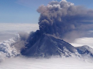
Volcanic eruptions are the stuff of stories and legends. They’re frightening, but at the same time, fascinating. Because of a volcano’s power to destroy, scientists spend a great deal of effort studying volcanic activity in order to make better predictions about when they will erupt and how far-reaching the effects will be. One recent 2010 eruption in Iceland was powerful enough to require grounding planes across much of northern Europe. As scientists learn more about the patterns of volcanic activity, they’ve also discovered a new tool that may provide even more detailed information to help with future predictions. It’s called GPS tracking.


Image courtesy of NASA Goddard Photo and Video


Monitoring a Volcano With GPS Tracking


We think of GPS tracking devices as monitoring things that move from one place to another—things like cars, bicycles, airplanes, and even people. But when an Iceland volcano named Grímsvötn erupted in 2011, scientist used GPS tracking to monitor the ground movement caused by volcanic activity. Knowing that the volcano was preparing for an eruption, scientist placed a tracking device on its side. The device began measuring significant ground movements about an hour before the actual eruption occurred. While more testing needs to take place, scientists hope that this is just the first of many steps in better understanding the activity of a volcano and being able to predict when the next eruption will take place.


Sigrún Hreinsdóttir, University of Iceland geophysicist and author of a journal article about the Grímsvötn eruption, hopes to use the data gathered from GPS tracking devices to determine not only when a volcano is getting ready to erupt, but also exactly when that eruption will be and how high the ash plume will reach. He posits that the GPS data recording the ground movement around the volcano can be used to calculate pressure changes in the volcano’s magma chamber underground. This information can in turn help predict how high the ash plume will be.


How GPS Data About Volcanoes Can Save Lives


The science surrounding volcanoes is fascinating, but more importantly, it can make the difference between life and death in a highly dangerous situation. Here are three ways the increased accuracy afforded by GPS tracking data can make a difference in the event of a volcanic eruption:


  • More warning for those living nearby—Volcanoes can still claim lives if people aren’t warned in time. GPS tracking can provide earlier warning of imminent eruption, giving nearby residents a chance to evacuate.

  • Better knowledge of ash plume activity—Volcanic ash plumes can cause planes to be grounded hundreds or thousands of miles away. Having an estimate of the size of the ash plume can give air traffic controllers the information they need to make better decisions about when and where to ground flights.

  • Estimates about the size of the eruption—Knowing the estimated size of the eruption itself can facilitate better decisions about who needs to be evacuated and what additional steps need to be taken.

When it comes to a volcanic eruption, those affected most are the people who live nearby and must worry about homes, crops, and property. With more detailed information, these people could not only have enough warning to escape the path of the eruption, but also to protect some of the things they care about.


Limitations to GPS Tracking Study of Volcanoes


With so much potential for better information, shouldn’t GPS tracking devices be able to predict each and every volcanic eruption? Yes and no. There are still some limitations to scientists’ ability to study GSP data about volcanoes:


Volcano locationsSome volcanoes, like Grímsvötn, are mostly covered in ice. Because ice sheets shift regularly, GPS tracking data about the volcano itself isn’t always accurate
Early stages of studyStudying volcanoes using GPS tracking devices is a relatively new approach. While many theories have been formed about how that data can be used, its accuracy hasn’t been clearly demonstrated yet

Hreinsdóttir hopes to gain additional support for his approach as he studies future volcanic eruptions. The more times he can accurately predict what the volcano will do based on the data he’s gathered using GPS tracking devices, the more he can fine tune his methods to get the best possible information.


Hreinsdóttir’s approach seeks to answer the two most basic questions about every volcanic eruption: When will it happen and how big will it be? Seismic instruments have given scientists some approximate answers to date, but Hreinsdóttir hopes that the GPS tracking data will revolutionize the study of volcanoes by providing much more detailed information about the size of the eruption and resulting ash plume as well as the ground movement.


Although we often think about the most devastating volcanic eruptions as having taken place hundreds or thousands of years ago, people still die in eruptions today. Perhaps with the help of GPS tracking, those deaths can be eliminated.


GPS Tracking In the Shadow of the Volcano

Saturday, April 19, 2014

GPS Technology a Boon to Domestic Violence Victims

Juana had grown so frightened of Mike that she had gone through the hassle of going to court and getting a restraining order against him. His drug use, threatening behavior, and physical abuse of her and their children had gotten so bad that she feared for their lives. The restraining order was a comfort, but she was still frightened, especially at night when she and the kids were home alone. If he showed up, she could call the police, but there was no way to know where he was or if he might show up unexpectedly. And if he did, what could she do? Or what if he was stalking her or the kids and showed up when she went to the store—or to a friend’s home? It might be too late then. If only there were a way to know where he was at all times, to know if he was breaking the restraining order’s restrictions—to know if he was close to where she was—to be able to notify the police before he arrived. That would bring incredible peace of mind.


Creative Commons Attribution: moggs oceanlane


Although this story is fictional, it’s based on the experiences of thousands of women who have been victims of domestic violence. Certain counties and municipalities are finding out that GPS technology can be a huge boon to protect such victims. How does it work? Citizens of Ramsey County, Minnesota, are finding out.


Domestic Violence: Some Statistics


The following sobering statistics are provided by the American Bar Association’s Commission on Domestic and Sexual Violence:


  • Eight percent of the female population will be stalked at some point in their lives.

  • Twenty-two percent of sexual assault victims are male; 78 percent are female.

  • Well over a million women are physically assaulted by a spouse or partner in the US each year. The same is true for more than 800,000 men.

  • Approximately one third of all female murder victims were killed by an “intimate partner.”

  • Roughly two thirds of women killed with firearms are murdered by an “intimate partner.”

  • Women make up more than 80 percent of all people killed by a spouse.

GPS Technology and Ramsey County


Although Ramsey County is geographically the smallest of all Minnesota’s counties, it is the most densely populated, being part of the Minneapolis-St. Paul-Bloomington, Minnesota-Wisconsin Metropolitan Statistical Area. In fact, it’s one of the most densely populated counties in the entire United States.


After hearing numerous tragic stories of women assaulted or even murdered by former partners who were under restraining orders, State Representative Clark Johnson authored a bill to pilot a program in Ramsey County that would monitor domestic violence offenders via GPS technology. He and others partnered with the Minnesota Coalition for Battered Women to get the program enacted.


How Does It Work?


In order for the program to work, both parties in domestic violence case must participate. The offender, usually a male who has been issued a restraining order, must wear an electronic ankle bracelet equipped with GPS technology. The victim (or potential victim), usually a female, carries a second device with her—somewhat larger than a cell phone—that informs her if her abuser is getting closer to her location than the restraining order allows. If that happens, authorities in a monitoring center receive automatic, immediate notification. Also, both parties (the victim and the perpetrator) get a warning signal on their devices. The defendant is instructed to change locations, and the victim is instructed to call local emergency services.


In Ramsey County, both the victim and the defendant must volunteer to participate. In early March 2014 27 pairs of defendants and victims were participating. Similar programs elsewhere in the country have met with success, finding that defendants equipped with the ankle bracelet and held accountable by GPS technology rarely, if ever, try to contact their accusers. The limited nature of the program in Ramsey County thus far (in its initial year, less than twenty out of 170 possible offenders agreed to be involved) precludes any far-reaching extrapolation of data; however, authorities have great hopes for it.


Ramsey County reports a couple of interesting situations regarding the GPS devices. On one occasion a device was somehow triggered even though the man was not within limits prescribed by his restraining order. Authorities figured out the problem, and no charges resulted. In another situation a defendant cut off his ankle bracelet in an effort to circumvent its effectiveness. That action, though, resulted in authorities’ automatically being notified. They showed up at the victim’s house to protect her. Even though the man did not show up, he was later located and arrested.


In early March 2014 there were bills pending in the Minnesota House and Senate that would potentially extend and expand the program. Clearly, GPS devices can play a large role in this area of law enforcement, protecting the health and lives of innocent women and children.


GPS Technology a Boon to Domestic Violence Victims