Monday, March 31, 2014

GPS Trackers for Mallards

Our neighbors to the north have launched a research project to study mallards and other waterfowl during their fall migration. In particular, they are trying to better understand the habitat needs of mallards, including how the habitats are affected by climate change, wind turbines and other factors.  Like many other wildlife research projects, the team will use GPS technology to their advantage. They hope to fit 40 ducks with GPS collars over the three-year research period, but so far can only afford to track one.


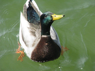
CC Image courtesy of Joanna Lee Osbornon Flickr


The lucky duck is called Rondeau Rhonda. It is named after the Rhondeau Bay, which is a popular area for waterfowl. “There is a direct correlation between what goes on at Lake St. Clair and what goes on at Rondeau Bay in terms of waterfowl, where they rest, where they migrate,” explained Mike Moynihan, public relations representative for The Rhondeau Bay Waterfowler’s Association. RBWA donated $1,000 to the mallard research project, allowing them to afford a GPS tracking device. The device provides real-time location data, which will come in especially handy during migration.


GPS tracking is very useful in all sorts of ways. Wildlife research has benefited a great deal from the technology. Typically, when we think of wildlife research, we think of Jane Goodall getting as close as possible to the animals and their natural habitat. In many place around the world, research is still done this way. But for teams fortunate enough to access funding for GPS collars, so much more information is available.


Animals are typically very sensitive to the presence of humans. It’s a survival instinct all of us animals have. When we’re out hiking, if we hear twigs snapping along the trail or otherwise sense we are possibly being followed, our instincts are to escape. At the very least, we aren’t going to be acting naturally. This is the case for many animals in the wild that are threatened by human presence. WIth GPS collars, researchers can monitor the movements of wildlife from a safe, non-invasive distance. Some studies also include motion-detecting cameras to pair with the tracking devices, which provide a more full picture of the habitat. Otherwise, some biologists simply travel to the GPS locations to observe the trails and habitats further.


The GPS tracking data “gives us wonderful data on movement patterns and migration and everything else,” explained Dr. Scott Petrie, Long Point Waterfowl’s executive director, in an interview with The Chatham Daily News. One of the major factors leading up to this research project was the noticeable decline in mallards and their wetland homes in the Lake St. Clair region of Canada. “There’s been a drastic decline in wetland acreage in and around Lake St. Clair,” Petrie said.


CC Image courtesy of uvw916a on Flickr


The study will look at where the mallards are feeding. “We kind of think that bait ponds and flooded corn probably provide important supplemental food for waterfowl.” On the Canadian side of the Great Lakes, Lake St. Clair and Long Point are likely the most significant wetlands. “Lake St. Clair is by far the most threatened, because most of the wetlands at Long Point aren’t drainable… they’re close to wetlands that aren’t dyked,” Petrie said. “Whereas, almost every wetland at Lake St. Clair is diked and very easily drainable.”


Petrie added, “there’s financial incentive for some people to pull the plug, drain their wetlands, then grow vegetables and possibly throw wind turbines in.” Agricultural land in this region is valued from $15,000 to $20,000 per acre. “But, if you put wind turbines into very important waterfowl habitat and the waterfowl avoid those areas, then that’s tantamount to habitat loss,” he said.


The tracking information “is going to have a direct impact on what we’re going to learn about mallard migration and so on,” Moynihan added. “We have noticed over the last few years – this is prior to turbines – that mallards are arriving later and later in the year.” Waterfowl tend to give plenty of space to wind turbines. Observation show that approximately 300 meters around each turbine mallards and other water birds are not found. Meaning, the birds avoid the turbines, likely because of the huge danger their massive blades pose to flying animals. Few, brave birds can be found within a kilometer diameter, called an “avoidance zone”.


“We want to see waterfowl populations flourish and we want to see strong ecology, strong biology and so on,” Moynihan added. Unfortunately, a large factor holding back the research is funding. They have been able to raise enough funds for one GPS tracker, but they hope to raise more money to be able to track a lot more birds. The more birds tracked, the more full, accurate and useful the tracking data will be. If you’re interested in donating to the cause, email spetrie@longpointwaterfowl.org or gdunn@longpointwaterfowl.org.


GPS Trackers for Mallards

Thursday, March 27, 2014

GPS Technology Used to Fight Devastating Poaching Problem

We’ve published many stories here about how GPS tracking devices are used in conservation efforts around the world to help protect and study endangered wildlife species. The technology is so versatile, new ways of using it are being discovered and developed all the time. On February 13, 2014, more than 40 world leaders signed their name to a declaration to combat the illegal wildlife trade industry. One of the best ways to do this includes tracking the wildlife with GPS devices.


GPS Protects Rhinos“The decimation of some of the world’s most iconic species through poaching and illegal wildlife crime has reached epidemic levels, particularly in the case of the African elephant. There can be no let-up in effective law enforcement on the ground to protect these species, and satellite tracking technologies are proving to be hugely helpful to wildlife managers monitoring populations,” said Charlie Mayhew MBE, Tusk Trust’s chief executive.


Once a species is declared endangered, it is protected by law. Unfortunately, simply passing a law doesn’t actually effectively stop poaching. A poacher is someone who hunts protected animals for profit. Typically, the poacher will only take a small part of the animal, like the skin of a tiger or the ivory of an elephant or a rhino, leaving the carcass to rot and waste. The skins and ivory were already valuable, due to the difficulty involved in hunting the wild beasts. However, after these animals were declared legally protected, the added risk involved drove the prices way up and into the black market.


The illegal wildlife trade industry generates around $16.7 billion every year, and the problem only seems to be getting worse. Poaching is absolutely decimating the majestic elephants and rhinos in Africa. In only the last two years, 10 percent of the African elephant population were killed for their ivory. Between 2011 and 2012, poaching of rhinos increased a whopping 43 percent. The good news is that world leaders are listening and better methods to protect endangered species are being implemented.


Volunteers and government employees do the best they can to protect elephants and rhinos in their area, but this is a very dangerous job. Due to the high profits made from poaching, people who are watching out for the animals are often caught int he cross fires. Many times the guards are unarmed, so there isn’t much that can be done if they do have the poor fortune to encounter a poacher.


Thankfully, new ways are being developed in order to protect the elephants and other endangered species with as little risk to human life as possible. “Satellites are increasingly becoming a reliable and resilient tool for monitoring and tracking wild animals,” explained Professor Nick Veck of the Satellite Applications Catapult, who’ve been teamed up with the World Wildlife Fund in Africa tracking elephants with GPS technology.


elephants“Recent advances in satellite-based technologies are changing the face of conservation and ecology, from identifying individuals and whole populations of species to monitoring changes in global forests,” Robert Freeman, who heads the indicators and assessments unit at the Institute of Zoology, Zoological Society of London. “Save the Elephant is combining satellite-uplink GPS tracking collars with Google Earth imagery to continually monitor elephant populations in the wild.”


“GPS tracking can follow the movement of any animal fitted with a tracking device – including after its death. Algorithms could be developed whereby park rangers are alerted by computers to suspicious movements recorded on the tracking device,” explained UCL’s Ray Purdy. Visual technology is also being used to monitor the protected animals. In addition to drones, cameras on satellite may soon be able to detect elephants and rhinos on the ground.


Along with GPS tracking of individual animals, they are hoping to spread awareness of the plight of the rhinos and elephants through a social media program called Instant Wild. Motion-activated cameras have been placed in Kenya, Sri Lanka, Namibia, Indonesia, the U.K. and here in the U.S. which capture images of anything moving in front of the camera. The public can access these images on the website or download the app. Under each image, people are asked if they can see an animal in the photo, effectively helping with the conservation and research project.


“Some animals are going to be harder to GPS tag than others,” Purdy added. “New very high resolution (VHR) satellites increasingly allow for visual surveillance, data collection and availability on an unmatched scale. The resolution on some VHR satellites from 2015 is expected to be between 10 and 25 cm, which would be able to see elephants, rhinos and other large endangered species.”


Unfortunately, this technology tends to be very expensive. A lot of it is top of the line and recently developed. For this reason, especially in impoverished regions where some rhinos and/or elephants roam, it was necessary to appeal to the summit of world leaders. If wildlife populations  are slaughtered to extinction simply because the local government couldn’t afford to properly enforce their protection, the whole world suffers a loss.


GPS Technology Used to Fight Devastating Poaching Problem

Tuesday, March 25, 2014

Researchers Use GPS Tracking After Lucky Boom In Snowy Owl Population

Snowy owls are quite majestic birds of prey. They are large in size and their white faces with brown coloring on the body make for a stunning bird watching opportunity. Because these birds prefer arctic conditions, bird enthusiasts in the United States rarely get a chance to spot them. Occasionally, a snowy owl is seen in the most northern states, but they tend to stay in within the Canadian borders. However, towards the end of November last year, there were many more sightings than normal, and much further south than was ever expected. The furthest south a snowy owl was seen this winter was in Florida.


CC Image courtesy of Will Thomas / Forge Mountain Photography on Flickr


David Brinker, a biologist from the Maryland Department of Natural Resources, almost couldn’t believe his eyes when he saw two snowy owls on a small beach in Maryland. “Something huge is going on,” he said to his team. “We won’t see something like this for a long time – probably for the rest of our lifetimes.” This massive boom in population is the biggest recorded on the east coast in around half a century.


“This winter has brought an unexpected invasion from the North, the largest migration of snowy owls observed in decades. The Arctic birds usually winter in Southern Canada, but this year they’ve been spotted as far south as Florida. As NPR’s Adam Cole reports, scientists are taking advantage of this unexpected visit by equipping a few of the owls with GPS tracking devices,” explained David Greene from WGBH News.


The snowy owl population naturally fluctuates from year to year with fairly predictably patterns with peaks every 4 years or so. This massive increase in owls can be traced to a recent over population of lemurs. Lemurs are rat-like mammals that are a favorite prey of arctic snowy owls. The abundance of lemurs essentially carpeted the canadian tundra. The owls killed way more than they could eat, and actually created nests out of the uneaten carcasses. With an abundance of food, the snowy owls thrived and laid nearly double their normal number of eggs. The baby owls were born with plenty to eat and grew into fat, healthy adult owls.


“They will eat pretty much anything they can jam down their throats – ducks, gulls, geese, muskrats, great blue heron,” explained owl expert, Scott Weidensaul. They’re a very big, very strong, very capable predator. On the Delaware coast, they were seen feeding on a dolphin carcass. That’s a new behavior we’re documenting this year.” Researchers jumped at the opportunity to study more of the snowy owls.


CC Image courtesy of Harlequeen on Flickr


“So Brinker and Weidensaul launched Project Snowstorm, their goal was to tag as many owls as possible with GPS transmitters,” Adam Cole reported to WGBH. “By studying the owl’s movements – for example the fact that they hang out at airports, the scientists hope to better understand their behavior and protect them from hazards. In less than two weeks, Project Snowstorm managed to cobble together a national team of volunteers and $20,000 in donations.”


Researchers trapped the owls carefully and took various measurements before attaching a tracking collar. “Then comes the GPS transmitter,” Cole added. “It’s a small light box that fits easily in the palm of your hand and it’s equipped with a solar panel and a chip that can hold five years worth of data. The owl wears it like a backpack with two thin Teflon straps wrapping around her wings. Brinker carefully sews the straps by hand so they fit the owl’s frame and don’t interfere with flight.”


“The owl takes off, gliding out into the dunes. Already her GPS unit is collecting data – longitude, latitude and altitude every half hour, and every three days her transmitter and the transmitters of the other 15 owls tagged so far will connect to a cell phone network and send all their data back to Project Snowstorm,” Cole said.


The GPS tracking devices will record the owls’ flight back north to the arctic and hopefully shed some light into how to best protect them in the coming decades. Climate change is already affecting the Arctic, where snowy owls live most of the year. Finding ways to protect the lemmings, the snowy owl’s primary source of food. In parts of Greenland and Scandinavia the lemming population may already be dropping, according to the Washington Post.


Snowy owls are amazing and beautiful birds of prey. Spotting these gorgeous owls thrills experienced bird watchers and the average Joe alike. Their white feathers, which serve to disguise them in the snowy Arctic, stand out stunningly in most other settings. We can only hope for another boom in the snowy owl population so that us U.S. citizens might have another chance to gaze upon the snowy owls in the wild. However, if another boost like this were to occur, it probably wouldn’t be for another 40 to 50 years.


Researchers Use GPS Tracking After Lucky Boom In Snowy Owl Population

Saturday, March 22, 2014

Where is GPS Navigation Headed?

For a few Christmas seasons in a row, there was one big gift idea—the one that everyone wanted, even though it was very expensive. Its capabilities seemed almost magical; it promised to increase efficiency by large margins for anyone fortunate enough to own it; and it was downright fun to use. It was, of course, the stand-alone GPS navigation device. During the first week of January each year, brand new navigators popped up on the dashboards of cars across the country. Today, however, many of those coveted devices lie unused, perhaps even consigned to the glove compartment. Is the stand-alone GPS navigator already a nostalgic product of the past?


GPS navigation deviceThe Claims Against Stand-Alone


What happened to take the GPS navigation device from its place of honor to the role of a forgotten tool in many cars? GPS technology progressed more quickly than developers anticipated, outgrowing the dedicated navigation device and spilling over into tablet computers and even cell phones. Before long, it just didn’t seem cost-effective to buy a dashboard-mounted device when you could simply download an app for a fraction of the cost. Some investors understandably panicked, claiming that companies like Garmin and TomTom were headed for disaster by relying heavily on stand-alone GPS technology. Those companies have certainly taken a hit from app competition, but they are far from being out of the race. Why?


Not So Fast


Technology moves quickly, but sometimes the human mind tends to jump ahead of even the fast pace of its own innovation. The usefulness of stand-alone navigators has probably not expired, despite the convenience of pulling up a map on a device you already own. Here are some comparisons of the two methods:


Smartphone GPS NavigationStand-Alone GPS Device Navigation
Restricts the use of other smartphone features (such as talking on the phone!)Provides service regardless of other activity
Uses large amounts of battery powerPreserves phone battery life; often draws power from car
Is not conducive to safe driving, due to small screen and handheld natureIs designed to be visible by the driver while also keeping an eye on the road

As you can see, it doesn’t take much time to come up with some good reasons to keep your phone in your pocket and switch on your dashboard GPS unit instead. Some phones do come with clips that allow drivers to attach their phones to the air vents on the dashboard for better map visibility, but the small size of most phones is still an issue.


Safety and Legality


As stand-alone GPS navigation devices exploded in popularity, safety experts quickly grew concerned about the safety issues inherent in blocking a portion of the windshield with a video display. Lawmakers eventually responded by dictating a maximum size for navigators and specifying where on the dashboard they should be mounted to allow the greatest amount of driver visibility.


With these rules in place, the GPS navigator is often actually a safer option than a smartphone with a GPS app. Without a dashboard mount, a handheld smartphone is extremely distracting to a driver, even more so if the app is not voice-activated. In fact, in more and more municipalities across the country, you could be ticketed for using a phone while holding it in your hand, whether you are using an application or simply talking. Residents and visitors in these areas have few legal options for using their smartphones as replacements for stand-alone GPS navigators.


A valid argument from iPhone users is that their phone can give them directions using voice activation, while their stand-alone device may not. With the right dashboard placement, this advantage may actually make the iPhone a safer choice than basic GPS navigators. But more new navigators are including voice activation without raising the cost significantly, and even the ones that do not usually have a touch screen that is easy to use while driving.


A Personal Decision


While it seems that nearly everyone you meet owns an iPhone or Android-enabled smartphone, there are still plenty of people who opt for a basic phone without a 3G or 4G connection, much less a GPS unit. Buying a basic navigator is far more cost-effective than paying a monthly fee on a new smartphone. On the other hand, people who already own a smartphone may see little reason to buy a new device for their car. It is, after all, a highly targeted theft item and may attract unwanted attention to your vehicle.


Each user must make his own decision, but the balance of pros and cons between phone GPS apps and stand-alone devices is likely to remain fairly even for some time. Perhaps the dashboard navigator, forgotten by many as they loaded their new smartphones with helpful apps, is due for a comeback this Christmas season!


Where is GPS Navigation Headed?

Thursday, March 20, 2014

Tracking the Trackers

If you are a naturally trusting individual, you may use your smartphone or tablet computer with hardly a thought about what companies or agencies might be pulling your location information via its installed GPS tracker. If you are more suspicious, or perhaps spooked by the recent revelations about NSA “snooping,” you probably wonder about it a little more. You might even go as far as disabling your device’s GPS tracker unless you are using it for a specific purpose. But does anyone really know exactly what location data their phone is sending out, and to whom? A fascinating new research project wants to change the answer from “no” to “yes.”


SatelliteWatchingCarsAnswering the Big Question


For many people, the big question is “who is getting GPS information from my phone?”. Parts of that answer lie buried in the fine print attached to the apps you download onto your device: murky disclaimers and notifications about using your location. The developers of these apps know that most users will never see those notifications, and even those that do see them will most likely forget about them quickly. If these users leave their GPS unit activated, the apps are free to collect and send location data freely.


Should we worry about this situation? It all depends on your stance toward privacy. You may actually enjoy receiving text messages and social media notifications about events close to your physical location. If that benefit outweighs your concerns about the possibility of government snooping and corporate misuse of your data, then you will not worry too much. But if you are trying hard to keep your private information private, your phone’s GPS tracker is likely a source of great frustration!


An Eye-Opening App


Researchers at Rutgers University are trying out a new app in a limited study that could change the way we think about GPS tracking information. The researchers, aware that most people have no idea what data companies are gathering from their devices, built an app that provides that information to its user.


At the moment, the app is not available to the public, and it was not really designed as a marketable product. Instead, the Rutgers team is interested in analyzing how awareness of GPS and other data collection might affect the everyday lives of people. During the study, researchers spoke with the participants on a regular basis to find out how the new information changed the way they thought and acted. The main take-away from the study? In general, people like finding out where their GPS data is going. They like it a lot.


How it Works


SatelliteThe people behind the Rutgers application report that it was fairly difficult to design a program that would look at the activities of other programs on the same device. The permissions needed to directly interact with other applications would be a programming nightmare, so the team took a different approach. Their app speaks directly to the phone or tablet’s system, asking for information about recent activity using its GPS unit. The answers to those queries give enough data to tell the user just what has been going on.


Applications use “methods,” predetermined phrases that request specific permissions to use GPS data on your phone. Think of them as passwords that an app must “say” to your phone’s system in order to use a piece of information. Here are a few of the most important methods that developers use in the area of location:


getGpsStatusAsks for the current status of the phone’s GPS unit
requestLocationUpdatesAsks for updates on the phone’s location based on provided criteria
removeUpdatesCancels location update request
getLastKnownLocationRequests an update on the last registered GPS position

The app designed by the Rutgers team uses “getLastKnownLocation” to ask the device directly about the last GPS data collection event. With that method, the app can find out what program accessed the information and pass the news on to the user. Users in the study were surprised, to say the least, about the level of GPS reporting that was going on behind the scenes.


Going On From Here


Good news for privacy-concerned technology users: the Rutgers researchers have plans to expand the app’s use using Google Play. Distribution to the public may be a slow process, but with the high level of interest in GPS data usage transparency, it is only a matter of time before this or a similar program hits the market.


Will public awareness change the way businesses seek and use GPS data? Maybe, but it is also possible that the convenience and enjoyment of GPS-powered functions will still outweigh privacy concerns in the minds of most people. Until then, read that fine print carefully the next time you install an app!


Tracking the Trackers

Wednesday, March 19, 2014

Soap Opera Drama Via GPS

Viewers of television dramas often express relief that their real lives bear little resemblance to what they see unfolding on the screen. Secrets, lies, and scandals might make for good TV, but they aren’t as welcome in the real world. The trouble with such complications is precisely that they are secret, kept hidden for months or years until they explode, destroying families and lives in the process. For better or worse, GPS tracking now plays an important part in triggering many of these explosions.


GPS Spouse SpyThe Suspicious Spouse’s Best Friend


Husbands and wives have long wondered just what their spouses were doing when they took that unexpected business trip, late night project at work, or long lunch break. But until now, it has not been possible for a suspicious spouse to follow along in secret. Now that GPS tracking devices are small enough to be hidden on a vehicle without being noticed, a wife can keep tabs on her husband’s unusual trip while she enjoys her morning coffee in the kitchen.


In Plant City, Florida, a husband called on GPS technology for assistance when he became aware of rumors that would have been more at home in a soap opera than in real life. His friends claimed that an affair was underway between his wife and the town’s police chief, and in order to verify the claim, he tagged the family car with a small tracker just before his wife left town.


To the husband’s dismay, the tracking signal showed that his wife was driving the opposite direction from the destination she had claimed. At the end of the long saga, the husband confirmed the rumors, confronted the two unfaithful spouses, and reported the affair to city officials in order to get the police chief fired. The attempt succeeded because the chief had conducted the affair during time on the city’s payroll.


Moral Objections?


We would have clear moral objections to a company or the government secretly tracking our location to find out if we were doing something wrong. George Orwell’s spine-tingling novel 1984 permanently spooked Americans concerning official surveillance, and any allegations of it instantly trigger firestorms in the media. But the situation is different where spouses are concerned.


spy vs. spyThere have been lawsuits brought by unfaithful spouses who were ratted out by secret GPS tracking. These claims stand on very shaky legal ground, however, primarily because the law sees married couples as single entities for most purposes. If a husband and a wife jointly own a car, for example, one of the spouses may legally install a tracker on it without informing the other. Here are a few situations, though, that would not be legal:


  • A private investigator hired to follow someone installs a tracker on his car

  • A woman installs a tracker on her divorced husband’s car

  • A husband installs a tracker on the car of another man he suspects of having an affair with his wife

  • Police use secret tracking to help a husband or wife track their spouse

In most cases, a cheating husband claiming that his wife violated his privacy by tracking him without his knowledge will not gain much sympathy from the legal system. The courts expect spouses to give up most privacy rights within their relationships, and that includes knowing where the other person is at any given time.


Love it or Hate It


It will be interesting to see what effects GPS tracking has on marriages across the country. Will spouses be deterred from starting affairs if they know that it is easy for their husband or wife to follow them around on their computer screen? That would undoubtedly be positive for society, but past knowledge of human nature suggests something different. The more likely result is that people will devise elaborate methods for avoiding and sabotaging GPS tracking devices. GPS jammers are already accessible and inexpensive, although federal law may soon catch up and outlaw them. Simpler approaches, such as switching cars or inventing stories that explain unexpected travel patterns, will probably be preferred by most cheaters.


The Park City, Florida case did not end well for anyone involved. The fired police chief ended up losing everything—even the woman in his affair abandoned him when she realized he was more worried about the status of his job than about the relationships in his life that were damaged by the situation. As tragic and painful as the story ended up, it is important to remember that GPS tracking was not the cause of the trouble, but merely the messenger that brought it to light. In happier scenarios, GPS may be able to end an affair as soon as it begins, or better yet, before it begins at all. Spouses across the nation will certainly be thankful if this technology allows them to keep soap-opera style drama out of their lives.


Soap Opera Drama Via GPS

Monday, March 17, 2014

Will GPS Devices Be Installed in Memphis Police Cars?

The idea of a Global Positioning System, or GPS, goes at least as far back as the 1970s. Today’s system, which utilizes numerous satellites to pinpoint the exact location of a GPS device small enough for a person to carry in his pocket, became fully functional in the 1990s. It is maintained by the US government; sister systems are being or have been developed in China, Russia, India, and Europe.


policecarsYou would think, then, that such a system would be widely used by all government agencies in the United States. That’s not the case, though, especially when it comes to local governments. Take the city of Memphis, Tennessee, for example.


Memphis Police Department: The Facts


The Memphis Police Department staffs over 2,400 officers and covers an area over 300 square miles in size. Divided into at least eight precincts, the department provides a wide variety of investigative services, including homicides, domestic violence, sex crimes, missing persons, and so on. The department’s Mission Statement reads, “Our purpose is to create and maintain public safety in the City of Memphis. We do so with focused attention on preventing and reducing crime, enforcing the law, and apprehending criminals.” And the department’s Vision Statement is “to create and maintain for the City of Memphis an environment of public safety recognized for its compassion and responsiveness to the needs, rights and expectations of all citizens, employees and visitors.”


In the first decade of the twenty-first century, the city installed more than a dozen red light cameras in order to cut down on the number of people who run red lights and, as a result, reduce the number of accidents, injuries, and deaths at Memphis intersections. According to a resolution passed in 2009, revenues from the red light cameras were to be used to purchase dashboard cameras and GPS devices for the city’s squad cars.


It’s been tough, though, for the city to actually make those improvements happen. Why? Like many other localities, finances have been a big problem since the turn of the century. In July 2013 Tennessee Comptroller of the Treasurer Justin Wilson wrote the city’s leaders, warning them that Memphis was in dire financial straits—and that the city’s problems went back nearly twenty years. Since that warning, the city has worked to solve its financial problems, but dashboard cameras and GPS devices for squad cars may fall victim to the tightened budgets.


A Little History


Here’s a timeline of events related to police department GPS devices and dashboard cameras in Memphis.


  • July 2009: Resolution passes stipulating that revenues from red light cameras be used to obtain GPS devices and dashboard cameras for Memphis Police Department squad cars.

  • March 2013: The city council clarifies the resolution, stipulating that 50 percent of red light camera revenues were to be used for dashboard cameras and GPS devices.

  • July 2013: Comptroller Wilson warns the city leaders of the serious financial difficulties they are in.

  • February 2014: Memphis Mayor A. C. Wharton calls for installation of the cameras and GPS devices.

Wharton believes that installing the devices will increase departmental efficiency, protect officers, and save lives. In the city’s current system, when police dispatchers are informed of a crime in progress, they must “poll” patrol cars to determine who is closest to the scene of the alleged crime, resulting in wasted time. A GPS device in each car would enable them to spot the closest officers immediately, cutting down on lost time and resulting in more arrests.


police-utensilsIn addition, dashboard cameras would provide hard evidence of what actually occurs during a traffic stop, an arrest, or any other event involving officers. The mayor indicated that the city has to spend money each year paying off judgments against the department based on “false claims.” A camera in each car, recording events as they unfold, could cut down on such claims, providing incontrovertible evidence of exactly how events unfolded.


Interestingly, a similar measure in Boston, Massachusetts late in 2013 met with resistance from officers. They did not like the idea of having such devices in their squad cars and being tracked everywhere they went, day and night.


How this will all pan out in Memphis remains to be seen at the time of this writing. Will funds be able to be allocated for the GPS devices and dashboard cameras? Will the officers accept them if they’re installed? Keep your eye on Memphis as the story continues.


Timeline: A History of the Memphis Police Department


YearEvent
1827First town constable, John Balch, appointed
1867First African American men hired as turnkeys
1873City council honored department for remaining on duty during yellow fever outbreak
1932Memphis dubbed “Murder Capital of the World” with over 100 homicides that year
1968Assassination of Dr. Martin Luther King in Memphis
1973Two unions form: Memphis Police Association and Afro-American Police Association
1986Implementation of Operation Involvement to improve police/citizen relations
1992First African American Police Chief, Eddie B. Adair
1998First female Deputy Chief, Brenda Harris Jones
2000New squad car design unveiled
2009Revenues from red light cameras to be used to equip squad cars with GPS technology


Will GPS Devices Be Installed in Memphis Police Cars?

Sunday, March 16, 2014

When Stolen Items Turn Hostile

When is a GPS tracking device worth $14,000? When it plays a key role in the apprehension of thieves and the recovery of stolen merchandise, a phone with GPS tracking can save prevent thousands of dollars from disappearing over the horizon. One such incident occurred in Palo Alto in January. After robbing a local business of phones, laptops, an iPad, and other electronics, two thieves loaded the merchandise in their stolen car and drove off. Unfortunately for them, the iPad in their car was equipped with the “Find my iPhone” app, which uses GPS tracking to help users locate misplaced or stolen mobile devices. An employee at the store activated the app, which led police to a parking lot and a parked car. When the two thieves pulled out of the parking lot, a police officer followed them. After determining that the car was in fact stolen, the officer pulled the car over, recovered the stolen property, and apprehended the thieves. Police credited the tracking app with helping them locate the suspects.


874390_42011309When Stolen Items Turn Hostile


No one plans to get caught when they steal something. Whether a thief meticulously plans the robbery or pulls it off on the spur of the moment, he always does so with the hopes of gaining something. But with GPS tracking, that stolen item can turn against him and testify of his guilt.


Police officers strongly recommend that phone users activate the “Find My Phone” app (or something similar) so that steps can be taken in the event of a theft. Of course, it’s always nice to get your phone back, but a phone that’s inside a purse, backpack, or other larger item can help police recover even more valuable items. They can even save lives. Many parents provide phones for their children for just such a purpose. If a child is kidnapped or picked up by someone who shouldn’t have access to that child, a GPS tracking app could make the difference between safety and injury or worse.


GPS Tracking and Law Enforcement


GPS tracking and law enforcement have been beneficial partners for quite a while. Not only has the technology enabled police to apprehend thieves, but also to accomplish a number of other essential goals. Listed below are some of the most important ways GPS tracking has made a difference to law enforcement departments across the country:


Phone or other small item theftLike the case in Palo Alto, many theft cases have been solved using a GPS-enabled phone or other device.
Vehicle theftIn addition to apprehending stolen vehicles, the devices have also been used in “bait cars.” Bait cars are vehicles placed intentionally by the police with the hopes of attracting a car thief. The GPS tracking device in the car can lead police directly to the perpetrator, breaking up theft rings and identifying chop shops.
Domestic ViolenceIn some states, courts have allowed the use of GPS tracking units to track domestic violence offenders. While usually done only in extreme cases, the devices provide an extra measure of safety for victims by sending an alert when the device-wearer crosses a perimeter or comes within a specified distance
Tracking sex offendersAnkle bracelets for sex offenders have been in use for quite some time. They allow police to monitor the wearer’s location in order to make sure the offender is not entering an off-limits area.

One other way GPS tracking can help law enforcement is that, with a warrant, in can be used to track suspected criminals. In cases of drug trafficking, theft, or other similar crimes, a device placed on a suspect’s car can lead police officers to the scene of the crime and enable them to apprehend the perpetrators. While tracking a suspect with a GPS unit has been questioned by civil rights advocates, the problem is with using the devices without a warrant. With a warrant, it is considered the same as searching a suspect’s house in a criminal investigation (which, of course, also requires a warrant).


Protecting Yourself From Theft With GPS Tracking


What can citizens do to keep themselves from becoming the victims of theft? Take normal precautions—and then, equip valuable items with a GPS tracking device. Whether the device goes on your phone, laptop, bicycle, car, or Grandma’s diamond necklace, it can make sure that even if a theft does occur, that item isn’t lost to you forever. GPS tracking enables police to recover items that might otherwise require weeks, months or years to recover—if they can be recovered at all—and to do it in a short amount of time. Don’t let yourself become a victim. Invest in GPS tracking for the items you value the most, activate that app on your phone, and make sure a thief doesn’t benefit from your stuff.


When Stolen Items Turn Hostile

Saturday, March 15, 2014

Unjammable Until Proven Jammed

The Canadian Army will soon run practical tests, or “missions,” on a recently approved anti-jamming device meant to help the Canadian military and its allies maintain a clear GPS signal even when hostile parties are attempting to jam their GPS. The GPS device that has been approved for the field run is the NovAtel GAJT-700ML antenna that is considered to be a pre-commercialized product for NovAtel. The field run will test the availability and reliability of the device in combat situations during battlefield days in March.


Satellite imageCanadian Government Working with Civilian Contractors


The current arrangement between the Canadian government and the civilian contractors involved in this project falls under the work of the Public Works and Government Services Canada (PWGSC). The PWGSC selected the contract from the Calgary, Alberta based Canadian company. This arrangement was also facilitated by the Canadian government’s Build in Canada Innovation Program (BCIP), which is involved with trying to create a safer and more secure government while also creating and allowing for more innovation from Canadian companies. The focus of the group is to especially target products that are in the later developmental stages and are presently pre-commercial.


What Happens on the Battlefield Stays on the Battlefield


Once the battlefield days begin, the GAJT-700ML will be tested for both availability and reliability. By military standards, the availability part of the equation will test and determine whether or not the GPS anti-jamming device can be ready at a moment’s notice under the conditions presented. It must be able to function as advertised to maintain the safety of the soldiers that are meant to be protected from this device. The reliability part of the equation will be determined at the end of each mission, or about a 24 hour window of operations. Reliability for military purposes in regards to GPS anti-jamming devices indicate that the device can not only function properly at startup, but also maintain functionality throughout the mission and over the entirety of several missions.


Timeline of the Testing Missions:


DateEvent
January 2014NovAtel announces agreement to test out the GAJT-700ML antenna with the Canadian Army
Early March 2014Field testing begins with battlefield days
End of March 2014After several battlefield days to confirm the availability and reliability of the anti-jamming device, the unit will be able to be evaluated to bring the testing period to a close

What’s in a Name?


The GAJT-700ML is just one of the available GPS anti-jamming devices that NovAtel is in the process of developing. They also have a GAJT-700MS, which creates GPS anti-jamming capability on ocean going vessels. This device will be able to function properly on both smaller boats and larger watercraft. There is also a GAJT-AE which is more portable and suitable for smaller scale activities. There is a possibility for advanced connections between NovAtel and the Canadian Army if the GAJT-700ML delivers the performance it promises.


How does the GAJT-700ML Work?


The jamming of signals and frequencies seems so farfetched, even in today’s world, that many don’t understand the importance of this kind of technology. This is not sci-fi and old space movies. GPS has become integral to the navigation and planning systems of many military and civilian devices. There exists technology today that can prevent devices from receiving GPS signals from the satellites. In a military situation, this can mean everything, as so many vehicles are equipped with GPS devices that will not run without receiving the signal from the GPS. Whole armies and navies could be rendered useless if the enemy uses jamming technology. It is this fear of the worst case scenario that justifiably runs up the urgency in having anti-jamming technology for military use. The particular device here works by using a null-forming technology that prevents jammers from jamming signals received by GPS devices on the land vehicles of the military.


Government Alphabet Soup


This project is important enough to get several levels of military involvement taking place. The main group given authority here is the PWGSC, but it also involves the DND (Department of National Defense), DLR (Directorate of Land Requirements), QETE (Quality Engineering Test Establishment), and the LFTEU (Land Force Trials and Evaluation). The testing of the device will be under the watch of the DND, which is tasking the main responsibilities to the QETE and LFTEU. Once the tests begin, the Artillery OPV (Observation Post Variants), which is part of the LAV III (Light Armored Vehicle III), will give the GAJT-700ML a run for its money as they put it through a variety of tests to see how effective and reliable the GPS anti-jamming device can be in the field.


Once these tests are completed, the Canadian military will be able to begin implementation of the anti-jamming device on its other land-based vehicles. If the GAJT-700ML proves to in fact be unjammable, at least to the military’s specifications, the Canadian military will have another tool at its disposal to help make Canada and the world a safer place.


Unjammable Until Proven Jammed

Friday, March 14, 2014

Trucking in the Payoffs for GPS Tracking Technology

Application of GPS tracking for fleets has reached a popularity level that almost makes it commonplace. While debates concerning personal preferences and specific employee concern continue to place bumps in the road of complete GPS-controlled tracking and widespread fleet control, most seem to see the theoretical benefits offered and many have opted to give the concept a try.


So now it’s time to ask the big question: Is GPS tracking for fleets actually working?


GPS Fleet Tracking


Mobile Resource Management


GPS tracking operating within the system of the Mobile Resource Management (MRM) created specifically to monitor many aspects of fleets, offers valuable feedback for owners and the general public. With clear statistics and easily accessible reports, evaluation of the efficiency of the MRM in pinpointing specific practices within companies has become much easier and far more error free.


Worth the Investment?


Installing the MRM and opening up the door to the benefits of GPS tracking quality control on the fleet level is obviously an expensive investment. While this expense makes it impossible for many fleet owners to make the investment and many others to hesitate, recent statistics demonstrate that the vast majority of those fleet owners who use the MRM are satisfied with the return of the investment and have actually saved at least as much money as they have spent through the benefits of the MRM.


Breakdown of Measurable Benefits


So, where is this recouping coming from? How can a relatively new GPS tracking technology device so quickly pay for itself and leave so many users satisfied within such a short period of its application and use? Although all the answers still haven’t come in and all the data is still being collected as MRM becomes more popular and widespread, the results that have turned up from recent reports indicate some specific ways that this technology is aiding fleets all across America.


The two most common areas of significant savings currently seem to be in the time management of employees and in the fuel bill of fleets using the MRM with GPS tracking technology. Other benefits that address even broader interests than the fleet company’s alone, such as the environmental concern of the emission of carbon, seem to be emerging through the use of this technology as well.


Employee Efficiency


van-fleet businessWithin the fleet context, measuring the efficiency of employees takes the form of miles and minutes. Ongoing automated records of minutes spent putting in the miles dramatically increases accountability and accuracy of reporting. Some of the specific ways that this takes place include:


  • Positive pressure to achieve

  • Documented delays

  • Driving details

  • Real-time records of complications

  • Unbiased reporting of policy conformity

While the ethics of GPS tracking may still be a matter of philosophical debate, the benefits are already beginning to weight the discussion. While GPS tracking with MRM isn’t necessarily targeted at detecting and ejecting poor workers, the motivation provided by the monitoring can benefit hard workers and the slightly more sluggish alike.


For one delivery company, savings related to employee time spent on the road have reached over $120,000. Without the never-tiring monitoring of a MRM, companies and employees may just have no idea how much time some old habits or random routines may be wasting.


The Fuel Fill


Most likely the easiest statistic to track, fuel savings seem to provide the biggest boost for MRM and GPS fleet tracking. Although the specific reasons why tracking would result in this type of savings vary from situation to situation, the results appear to remain consistent about the fact that tracking does indeed stimulate, motivate, and somehow create drastic savings in fuel costs for fleets.


Reducing the amount of time in which a truck remains running while not on the road is one of the aspects that enables this saving as well as providing the eco-friendly benefit of less carbon in the environment. As fuel prices continue to skyrocket without much hope of coming back down again and as concerns for the purity of air in cities and industrial areas continue to increase, savings in both these areas carry a lot of weight and desirability.


Accumulated Benefits


Using these popular categories of benefits and adding in some additional considerations, such as vehicle maintenance savings, the reports from fleet companies using MRM GPS tracking record numbers that seem to leave no question about the accumulated benefits of this system.


As a single example, with statistics from merely three different companies managing fleets of varying sizes, the combined savings for a single year total up to over $340,000.


As data continues to be collected with the expansion of MRM GPS tracking use among fleets, these numbers could become even more astounding. So far, the results that are trucking in seem to indicate that the predictions of benefits are coming true and the investments of fleet owners are paying off.


Trucking in the Payoffs for GPS Tracking Technology

The Many Uses of GPS Technology for School Buses

A recent story out of Detroit tells a brief tale about a young man age 25, a cold day, and GPS technology. In the story, the driver of a school bus had started the school bus in the Safeway Transportation parking lot and then went into the office to allow for the vehicle to warm up. After some time had passed, the driver returned to his vehicle to find it missing. During the bus thief’s joy ride, Michigan state police were alerted to the fact that a hit-and-run had occurred involving a school bus not far from the Safeway Transportation center. Police were able to find the car thief once the bus was disabled. When the bus had come to a stop at one point, Safeway was able to use the GPS technology to disable the bus from starting again, causing the thief to flee on foot to an apartment building, where he was apprehended by the police.


schoolcrossingguardWhat GPS Technology did to Help the Police


Once the police were alerted to the theft, the GPS tracking technology installed on the school bus made the hunt very easy for police. Once they began tracking the bus, it was quickly found and circled, despite the attempts by the thief to cross onto a toll road, which was unsuccessful due to not having enough money for the toll. The GPS technology installed also allowed the bus company to remotely turn off the bus and prevent it from driving off once it came to a stop. The thief apparently stopped the bus close to his residence and was even recognized by a neighbor as he fled inside. Upon being caught by the police, it was determined that the suspect would need to undergo some psychological tests, as he apparently suffers from a mental illness. He was transported to Detroit Receiving Hospital for the tests.


What can GPS Do for You?


Today’s GPS technology is so much more than just finding your way in unfamiliar locations. It is even more than just finding lost things and turning off engines. What could GPS technology do to help schools and school buses to be more efficient and safer for students and the taxpayers that support them?


·         Student Notification: In some parts of the country, school can start very early and students are sometimes required to wait outside in cold or freezing temperatures waiting for their school bus to arrive. If parents had a way to track their child’s school bus location in real time, they could help their child know when to make the journey to the bus stop and not have to wait for it in the cold. Even though everybody over 40 walked to school “in the snow, uphill both ways” when they were a child, it doesn’t mean that today’s student needs to suffer the same discomfort.


·         Better Routes: The GPS navigation can allow users to track where the school buses are driving and also when they are there. This technology could be used to help bus drivers find the best routes for the students and determine if more drivers would be more cost efficient due to the number of students and routes to take. If a driver continuously gets stuck in traffic, an alternative route can be determined that can save the taxpayers money in wasted gas and hourly wages.


·         Improved Safety and Awareness: Parents can also be informed of delays and changes to bus schedules by being able to track the progress of their child’s school bus. If junior is running late, it will be easier to determine if his bus is still on the road or if he should already be home and might have just stopped at Johnny’s house. Today’s parents want to know right away where their children are (rightfully so) and GPS technology being used on school buses is one way to create that knowledge.


·        School Kids GPSRemote Control: The GPS device used to track and stop the school bus in this case could be useful in preventing another type of unauthorized driving: from the students! As much as it would be desirable to simply keep the bus driver in the driver’s seat at all times, there may be an unavoidable situation that opens it up for a rambunctious pre-teen to take the wheel and take the bus for a joy ride. The remote access could limit the damage caused by such an event, whether it could be from a student or a simple car-jacker.


The possibilities are endless for school districts. While there would inevitably be an upfront cost for this GPS technology, the potential savings might be enough to cover it in a short amount of time. Parents today want more peace of mind when their children are out of the house, and this is another way to get an extra set of eyes watching out for them.


The Many Uses of GPS Technology for School Buses

Wednesday, March 12, 2014

Stiffer Penalties Proposed for Tampering With a GPS Tracking Ankle Bracelet

GPS tracking ankle bracelets have been used for several years to monitor known sex offenders, both in America and around the world. The devices enable law enforcement to monitor the whereabouts of these offenders and to ensure that they comply with the requirements of their release. But sometimes, offenders find ways to remove the bracelets, enabling them to commit additional crimes or to simply disappear. In order to address this problem, government officials in Queensland, Australia have instituted an automatic one-year prison sentence for tampering with a GPS-enabled tracking bracelet or anklet.


Supreme Court GPS TrackingHistory of GPS Tracking for Sex Offenders


Before GPS tracking bracelets gained traction in law enforcement, sex offenders were monitored using traditional methods like regular meetings with a parole officer and weekly meetings or classes. But despite these measures, many paroled offenders went on to commit additional crimes. Since they could not be monitored at all times, it was fairly easy to slip through the net and find ways to continue their criminal behavior.


In addition to these traditional methods, GPS tracking anklets and bracelets are now used by a majority of law enforcement departments to keep better track of sex offenders in the system. The devices allow for monitoring of known offenders twenty-four hours a day, seven days a week. If an offender enters an off-limits area such as a school or child-care facility, police officers can detect that offense and take immediate action.


Effectiveness of GPS Tracking Bracelets


The real question is this: do the devices work? According to a study sponsored by the National Institute of Justice, the answer is yes. The study found that:


  • Paroled offenders who did not wear GPS tracking devices returned to custody almost 40% more often than those who wore the devices

  • The GPS-wearing group experienced 12% fewer arrests of any kind

  • GPS-wearing offenders were more likely to comply with parole requirements

  • Offenders who did not wear GPS tracking devices had their parole revoked more often than those who wore the devices

While instituting a GPS tracking system for sex offenders does entail an additional cost, that cost is only $8 more per day than traditional monitoring methods. And that extra cost pales in comparison with the hundreds of thousands of dollars needed to keep criminals deemed too dangerous to release into society in dedicated institutions after the completion of their prison sentences.


Omaha Criminal TrackingWhy The Devices Sometimes Fail


Unfortunately, GPS tracking isn’t a fail-safe method. Sometimes offenders remove their bracelets and manage to elude parole officers, going on to commit additional crimes. In some cases, alerts may go unchecked due to lack of personnel. And in California, recent changes to the law mean that offenders who tamper with their bracelets now go to county jails rather than state prison. Crowded conditions often mean these offenders receive little to no jail time. But that’s the fault of the system, not of the GPS tracking device itself. Lawmakers in the state of California and elsewhere are working to find better solutions that keep people safe and prevent repeat offenses. Because GPS tracking devices have a proven track record of reducing repeat offenses, the fact that they sometimes fail shouldn’t be seen as a deterrent to using them in the first place. Ultimately, the cost of implementation is well-worth the lives that can be saved by drastically reducing the number of additional offenses committed.


What Lawmakers Are Doing To Correct the Problem


Tracking sex offenders with a GPS anklet has revolutionized the way law enforcement deals with known paroled offenders. But that doesn’t mean they can’t make improvements to the system. The Queensland measures are one example of how departments can take action to reduce the number of repeat offenses even further. Law enforcement departments in other locations have introduced proposals such as:


  • Changing laws that send offenders to county jail for tampering with an ankle bracelet to require a state prison sentence instead

  • Three-year prison sentences for removing or tampering with an ankle bracelet

  • Making ankle bracelet tampering a mandatory felony

  • Increased bond for those charged with a sex crime

Police officers stress that citizens should still feel safe, despite the fact that offenders can remove their ankle bracelets. When a bracelet is cut or stretched, the police receive an alert and in most cases, they can catch the offender within 48 hours.


GPS tracking ankle bracelets have provided part of the solution to overcrowded prisons and broken paroles. While they can’t solve the problem of limited personnel, they can provide 24/7 monitoring capability, which would be impossible even with more officers on the force. Lawmakers hope that stiffer jail sentences will prove to be a greater deterrent to tampering with the devices, keeping sex offenders where they’re supposed to be and making communities safer for everyone.


Stiffer Penalties Proposed for Tampering With a GPS Tracking Ankle Bracelet

Tuesday, March 11, 2014

Missing Malaysia Airlines Jet: GPS Questions

EDITOR’S NOTE: At the time of this article’s writing, the search for the missing Malaysia Airlines jet is still underway. Hopefully it will have been found by the time of publication, but the GPS issues raised by the tragedy are relevant whatever the outcome.


Air TravelAs people around the world watch, naval forces from numerous countries comb the ocean around Vietnam for any trace of Malaysia Airlines flight 370. There have been several false hopes of success, as searchers found unrelated bits of debris and oil remnants floating on the water. As the days wear on with virtually no developments, those who know something of modern technology can’t help but ask: why hasn’t GPS capability allowed us to find the plane right away?


No Signal to Follow


GPS is an incredible tool that has given law enforcement and military agencies the ability to quickly locate countless lost people and items. But, like most technology, it depends on a human action for it to work correctly: turning it on. If a GPS tracker is deliberately disabled or simply not turned on through neglect, it is useless. Early knowledge of the Malaysia Airlines situation suggests that the plane’s official GPS signal was lost abruptly during the flight, whether due to an accident or sabotage. Thus, the most accurate data can only show the last reported location of the plane. How far it traveled after the GPS signal disappeared is an open question at this point.


Other GPS Sources


It’s extremely likely that the GPS unit installed on the plane was not the only device on board with GPS capability. With over 200 passengers aboard, we can assume that scores of GPS-enabled cell phones, tablets, and computers could theoretically broadcast a tracking signal. In fact, this possibility seemed likely when family members were startled to see that their lost loved ones appeared to be logged in to social media accounts. The information was given to government officials, but does not seem to have resulted in finding a usable GPS signal broadcast by personal devices.


According to experts, an explosion in midair or a plane crash in the ocean would probably have made it impossible for the devices on board to beam a GPS signal that would reach satellites. Even if a cell phone survived the crash intact, once under water it would not be able to get its signal out. As reliable as GPS navigation seems to us during normal use, all it takes is loss of signal due to a tunnel or skyscrapers on either side to remind us that it has some very real limitations. The apparent online activity of lost passengers following the plane’s disappearance is difficult to explain, but if it was the result of people using their personal devices, we can assume that a number of GPS signals would have allowed officials to triangulate their exact location.


What Could Have Helped


SatelliteHindsight is always 20/20, and there is no shortage of experts (some self-proclaimed) identifying the available technologies that may have been able to save the plane, or at least provide more useful information about what happened after the GPS signal disappeared over the ocean. Here are a few of those options:


Secondary radarBackup to standard radar trackingDoesn’t always work over large ocean areas
Expanded “black box” technologyWould theoretically send real-time updates on plane’s vital signs during a flightExtremely expensive to install and operate

Expense is the largest single reason that airlines have not upgraded tracking technology. In developed countries like the U.S., government regulations dramatically raise the cost of testing and implementing new devices. Rather than paying these high costs, airlines rely on sometimes outdated methods. In less developed countries, the situation can be even worse, as airlines have less money to work with in the first place.


Back to the Basic Problem


Whatever equipment is aboard a plane, it is subject to failure if it depends on the action of human operators in order to work properly. In a disturbing reminder of the possibility of human failure, two men were able to board the Malaysia Airlines flight using passports that did not belong to them without being stopped. Officials now believe that the two men were not terrorists, but the lapse in security raises the question of what other policies (perhaps related to GPS devices) were not followed as the flight progressed.


Is more automation the answer? A computer “glitch” is always a possibility, but the chances of malfunction are far, far smaller if human unpredictability is removed from the equation. Whatever the outcome of the ongoing search for Malaysia Airlines flight 370, it is likely that in the weeks and months to come, we will see a call for upgraded flight tracking, probably centered on making GPS more reliable.


Missing Malaysia Airlines Jet: GPS Questions

Monday, March 10, 2014

Safe in Plain Sight

Police in Arizona were able to use a GPS tracking technology fitted camera to track and arrest a suspected burglar in January after a house was broken into and robbed. The house was broken into despite several burglar alarm signs on the premises and the burglar made off with about $10,000 worth of electronics and jewelry. Fortunately for the homeowner, he had the forethought to plant several GPS tracking devices among his personal belongings that allowed the police to find the suspect with very little problem within about 24 hours. For all that was missing, only some jewelry was not recovered, which had probably been pawned off earlier. This story continues the impressiveness of GPS tracking devices to make sure your belongings are safe even in plain sight.


protect valuables gpsWho Needs a Safe?


The victim in the above case was Allen Crosby, who had purchased several GPS trackers to put on his electronics just in case such an occurrence happened. Once the items were stolen, it was as simple as using a cell phone app to track the burglar. Using the app, the police were able to figure out where the suspected burglar, James Yunis, lived, and then followed a series of beeps emanating from the GPS tracker to locate the exact location of the equipment near the camera that had the device embedded in it. The use of the GPS tracking in this case highlights the effectiveness of this kind of device as a means to deter crime and also find criminals.


Deterring Crime


While the technology for using GPS tracking devices in valuables is designed to be small and not noticeable, it has a huge potential for deterring crime. While it would not be smart to advertise that your valuables have GPS tracking devices, as the technology becomes more available, burglars will be stupid to assume that anything they steal of value is without some kind of device to find out their whereabouts. Could a criminal simply remove the device? In some cases this will happen, but most of the time, they will probably not notice the device. It will, however, make the burglar think twice about what he is going for.


Finding Criminals and Belongings


This is the real benefit to using the GPS tracking devices in your valuables. One part of this is finding the thief and hopefully preventing him from stealing from others. A bigger issue for most people is the potential to get their belongings back, which might range from very valuable to very sentimental to very important and irreplaceable for you. No more will you have to hope that your lost belongings can be found at a random pawn shop down the road. You will be able to pinpoint where your stuff is and get it back as soon as possible instead of hoping to get it back someday. Once your belongings are restored, it will be easier to get on with life as it was before.


Safe Even in the Open


Child Services GPSWhile it is a good idea to keep your valuables under lock and key, using a GPS tracking device might allow you to display your prized possessions more without fear of losing them. We lock up things to keep them safe, but in a sense, once they are safe, they cannot be used or viewed and end up wasting away in storage. If you can keep your belongings out where they can be seen and enjoyed, equipped with a GPS tracking device, it will actually help you feel free and safer.


Ways to Stash Your GPS Tracker or Micro GPS Unit


Using your smartphone device, there are several products out that allow you to track items using a GPS tracking device or micro GPS unit. Some ways to use them to protect property and people:


Embedded into a camera – used in this burglary to help recover the lost items.


Stashed in your child’s backpack or purse – to keep tabs on your children as they play or go out.


  • Embedded into a briefcase or suitcase – what might look like a convenient way to carry away your valuables to a burglar might be the trick that helps track them down.

  • On a pet’s collar – yes, there are products out there small enough to be located on the collars of man’s best friends and their feline compatriots.

  • Put one in your car to keep tabs on your teenage driver – kind of like a LoJack device, but this will not only help if your car is stolen, but also to make sure your teenage drivers are going where they are supposed to be going.

  • In addition to stand alone devices, there are also many items, like cell phones or tablet computers that allow you to track them through various apps that are available.

The applications are nearly endless for using GPS trackers. Not just for personal security for your property, but also to give you peace of mind about the ones you love the most. This kind of device can save more than your money.


Safe in Plain Sight

Thursday, March 6, 2014

GPS Mapping Project in Clermont County, Ohio

A Little History


Clermont County, Ohio, has a proud and interesting history. This little county’s roots involve not only native American peoples such as the Shawnee, Cherokee, Wyandot, Mingo, Miami, and Delaware tribes, but also French royalty (the exiled king of France lived there in the early 1800s) and a Puritan utopian settlement. The county’s Historical Society is an active force in the community, and the county promotes good citizenship through participation in events such as the Ohio Saves Week (to promote the wise use of money) and the promotion of its two state parks. Nearby attractions include a variety of museums (including Ulysses S. Grant’s birthplace), a vineyard, the Freedom Trail (a tour of 33 Underground Railroad sites), a raceway, and “Jungle Jim’s International Market.”


mapToday the county has a relatively low population density—less than 400 people per square mile. The rural nature of the county as well as its low population has made it a prime candidate for GPS mapping, a project that the county undertook early in 2014.


Clermont County and GPS Mapping


Using mainly funds provided by the Ohio Department of Transportation, the county partnered with another Buckeye State entity, Digital Data Technologies Inc. (DDTi), to map all the county’s roads and create an accurate database of addresses at the same time. The partnership was formed as a part of Ohio’s Location Based Response System program, a program that dates back to 2011. According to an Ohio government website, “The Location Based Response System (LBRS) is an initiative of the Ohio Geographically Referenced Information Program (OGRIP). The LBRS establishes partnerships between State and County government for the creation of spatially accurate street centerlines with address ranges and field verified site-specific address locations” (http://ogrip.oit.ohio.gov/ProjectsInitiatives/LBRS.aspx).


According to information provided by the Clermont Sun newspaper, accurate GPS mapping is accomplished by having two technicians drive a DDTi truck equipped with GPS technology down all the county’s roads at a slow rate of speed. Digital technology onboard creates accurate maps of the roads, and the truck’s operators verify and mark on a map each address—either a home or a business—on the map. The result, hopefully, will be accurate and up-to-date information on the roads and addresses of the county’s 66,000 households and places of business.


GIS, GPS, and DDTi


Back before the turn of the twenty-first century, the Ohio State Center for Mapping worked with DDTi’s founders to create mobile data collection vehicles. The goal was to provide accurate street addresses for use with geographic information systems (GIS). Without accurate information, such a system is largely useless.


SatelliteWatchingCarsSo what’s the difference between GIS (geographic information systems) and a GPS (global positioning system)? Clearly the two are closely related, both having to do with mapping and locations. GIS is the more all-encompassing term, though. It includes any system—from hard copy (i.e., paper) maps to electronic databases—that includes specific information about where data is located. For example, where crimes have occurred over the past year. Or where all the intersections are in a city. Or, in the Clermont County example, where the county’s highways and roads run and where businesses, homes, or points of interest lie along those roads.


A global positioning system, on the other hand, uses satellite technology to specify the location of a certain person or vehicle. A small device makes contact with a number of satellites that pinpoint the device’s position, showing the user where he is on a map. Obviously, then, GPS technology is useful in creating accurate GIS maps, but the two systems are distinct from one another.


Since as far back as 1993, DDTi has been working with state and local government agencies as well as private corporations to provide “spatial solutions”—i.e., maps and mapping tools—with the goal of providing mapping information that is as accurate as possible. The company’s Mission Statement reads, “Ensuring the safety of lives and property by providing accurate spatial solutions.”


What’s the Purpose?


Of course, having accurate maps and addresses is quite important to county officials and agencies, including emergency response networks, police, and state patrols. When the County Dispatch Office receives an emergency call—say, for an automobile accident, theft, fire, or assault—having accurate, up-to-date, verified information as to the location of the event can save precious moments and can result in saved lives. Information gleaned can also be shared with other counties and can provide data that can be used statewide as well.


The process of GPS mapping the county was begun early in 2014. Officials state that their goal is to have the entire project completed by early summer.


GPS Mapping Project in Clermont County, Ohio

Wednesday, March 5, 2014

GPS Tracking: A Worthwhile Investment for Schools

With snow blanketing much of the northern part of the country, worries about travel safety can take center stage, especially when it comes to children who ride the bus to school each day. Parents need a reliable way to know if there will be delays, if the bus is running on schedule, and if their children made it to school safely. For several northern Illinois school districts, GPS tracking is providing that peace of mind.


school bus gpsMore Than Just Location Information


GPS tracking is well-known for its ability to provide accurate location information for people, vehicles, and just about anything else. But today’s models can tell you much more than the coordinates of the school bus your child is riding. In Rockford, Illinois, school districts use GPS tracking units combined with key cards issued to each child to provide all of the following information:


  • News about delays—By keeping close tabs on each vehicle in the school district’s fleet, school officials can let parents know if a bus is running late due to icy roads or other adverse conditions.

  • Route speeds—Monitoring a bus’s average travel speed lets officials know how quickly the route should be completed, making it possible to answer parent questions in much more detail.

  • Idle times—Keeping tabs on the time a vehicle spends idling can help fleet managers determine where efficiency needs to improve and to identify whether it’s a question of inefficient driver habits or students routinely running late.

  • Child location—Schools sometimes get calls from parents about whether their children boarded the bus for a ride home or whether they need to be picked up. When schedules conflict or weather conditions necessitate different travel plans, the electronic key cards carried by each student make locating an individual child much easier. Children swipe their cards when they board the bus and when they leave. Officials can then check via computer to determine whether the child is on the bus rather than using the old system of having a driver pull over and check seats.

Safety First


Child safety is of paramount concern for school districts as well as for parents. Equipping buses with GPS tracking systems better enables school officials to ensure that children board the bus when they should and that they reach their destinations safely. Better information about travel times, delays, and stops helps put parents’ minds at rest, making it possible for them to receive a concrete answer rather than waiting until the driver can be reached. In addition, some school districts are considering providing parents with access to a portal that allows them to check bus locations and travel information online rather than having to call the school.


While GPS tracking is often considered for efficiency, district officials believe that efficiency is closely related to safety. Especially when roads are covered in snow and ice, it’s common for bus routes to take longer or for buses to get stuck somewhere along the way. Better knowledge means less pressure on the driver, giving him or her freedom to make safety-conscious decisions rather than trying to keep a strict schedule even in dangerous conditions.


Cost of GPS Tracking for School Buses


Equipping all the buses in the Rockford School District with GPS tracking units cost about $350,000. That’s a hefty price tag, but one that school officials believe is well worth it in terms of student safety and driver efficiency. Most fleet managers who invest in GPS tracking report savings in fuel costs and other cost reductions that covers the cost of the system in a relatively short period of time. And with thousands of families trusting their children to the school system each day, officials need a reliable way to keep track of individual students and put parents’ minds at rest when questions arise.


gps tracking for school bus fleetsIs GPS Tracking a Worthwhile Investment?


While GPS tracking isn’t used universally yet, school districts that have implemented the technology have reported good results in almost all cases. Budget-conscious citizens and board members can see the savings in terms of fuel and efficiency, while safety-conscious individuals are pleased to see greater child monitoring and protection in place. It’s a win-win for everyone involved.


The Rockford School District bus systems also provide information about the operations and mechanics of each bus on a real-time basis. With more precise data in hand, school officials are in a better position to answer parent questions, make decisions about individual bus maintenance schedules, and implement measures to create better driving habits if they notice a concern.


Ultimately, the decision to implement GPS tracking is a decision to put child safety first in the school district. No parent likes to worry about the whereabouts of a child, and systems like the one used in Rockford can eliminate most concerns. With better tracking in place, it’s much less likely for a child to get overlooked and parents can immediately be informed when anything is out of the ordinary.


GPS Tracking: A Worthwhile Investment for Schools

Tuesday, March 4, 2014

GPS Tracking in the Vending Venue

Among the fleets currently pioneering the use of GPS tracking technology on a regular and sustained basis are the specific fleets of vending delivery. Although similar in many ways to fleets of other types of businesses, vending delivery does place some special demands on these companies that perhaps make the GPS Car-Fleet-Novembertechnology even more effective.


As the economy continues to tighten down on private or small businesses of every sort, especially those that include face-to-face interactions and physical goods, saving costs and increasing assets become not only desirable, but absolutely necessary for survival and growth.


Can costly GPS tracking technology units really help in the vending venue? Is fleet tracking important for helping a vending company succeed? Although an initial risks-versus-benefits analysis may leave some question, those who have taken the plunge are beginning to report the gains in both expected and unexpected areas.


Security Coverage


Delivery personnel usually make the daily rounds alone, efficiently enabling all the employed drivers to cover as broad an area as possible. While the security of drivers is often taken for granted, crimes against a person carrying out a delivery have increased so significantly that in recently, the New York senate passed an amendment regarding the issue. The stated purpose of this amendment was to treat these crimes more seriously by giving them their own specifications under the penal law.


The security of a delivery person can be threatened in any of the following ways:


  • Theft

  • Robbery

  • Gang attack

  • Ambush

Among the listed top 25 most dangerous cities, big cities are definitely represented, but smaller cities located in areas of the country normally considered as less violent are also included.  Security is no small issue for delivery drivers in a majority of the cities in America today.


With GPS tracking technology, drivers can enjoy more non-stop security coverage as they fulfill their duties. Vending companies can also be less concerned about experiencing the loss of stolen goods or vandalized vehicles. Constant surveillance also provides valuable information to police regarding those who make a practice of crime and vandalism.


Reports about many different types of rescues and recovered vehicles and property due to GPS tracking technology are already familiar within recent news releases. These successes so far should encourage companies considering the option to apply this additional security to the realm of delivery personnel and vending companies vehicles.


Maintenance Matters  


GPS SatellitesFor companies owning and depending on fleets, maintenance of vehicles consumes a large portion of operating costs. With the reported and documented increases in estimates for owning vehicles and the ongoing upward direction of prices for diesel, fleet owners have to find as many ways as possible to tighten the figurative belt and cut costs.


GPS tracking technology has seemed to help with this as well. Several aspects of the data collection aid in the following cost-saving practices:


  • More efficient routes

  • Early notification of needed repairs

  • Less idling of the engine

Practical changes to wasteful habits that the collected data reveals enables accumulated savings that can add up to actually pay for the investment of installing a GPS tracking technology system. Several fleet owners are already releasing statistics that prove the technology is doing its work and saving pennies that add up to thousands of dollars.


Asset Assistance


Anyone involved in business understands the importance of building as many assets as possible within the company itself. GPS tracking technology for fleets within the vending industry may actually do this in an unexpected or easily overlooked manner.


With the installation of efficient tracking and ongoing updates, the investment in vehicles increases in ways that will be easily covered in a case of loss. This along with the additional benefits to the vehicles themselves through the increased maintenance adds up significantly for those in charge of crunching numbers for the company.


Computerized monitoring of vehicles and employee use also enhances the assets that the company already owns and uses. Despite the response of many to the idea of monitoring at the workplace, significant results have already been reported and no major complaints have been filed by employees under the new system. In fact, employees themselves may find that they are benefited by the additional motivation to accomplish tasks quickly and thoroughly.


Save-Save Situation?


Although each vending company will have to evaluate the benefits for its specific fleet before making an investment in GPS tracking technology, the hidden benefits, as well as the more obvious, could begin gaining popularity among this specific group of fleet owners. As reports from those already using and experimenting with this technology continue to show up, vending delivery may just experience some changes that could open new doors. GPS tracking technology can’t solve all the problems of business owners today, but it may continue to be a tool to dealing with small ones that always add up.


GPS Tracking in the Vending Venue

Monday, March 3, 2014

Federal Program Provides GPS Tracking Devices for Children With Autism

Child safety is at the top of the priority list for every parent. Making sure children know how to cross the street safely, what places they may and may not visit, what to do in the event of a fire or other dangerous situation, and numerous other safety issues are one way parents seek to protect their children from the dangers of daily living. Families who have children with autism face even greater challenges as they seek to provide a safe environment for their children while protecting them from harm. But now there’s a new way to add an extra layer of protection, and it’s paid for with funding provide by the Department of Justice. It’s called GPS tracking.


GPS tracking childrenFederal Grant Funding for GPS Tracking


Families of children with autism can now obtain GPS tracking devices for those children, thanks to a new program funded by the Department of Justice. The devices can be obtained through a local law enforcement agency or office. Officers, school personnel, and parents can also receive training paid for using funds from the grant.


Autism groups are very happy about the decision, saying that the devices can save lives by keeping tabs on the children even if they wander. One of the most frightening circumstances for a caregiver is to turn around and discover that the child has wandered off, especially in a potentially dangerous place. GPS tracking devices can alleviate some of that fear by immediately locating the child and providing an exact location to the caregiver.


GPS Tracking for Children with Autism


Because children with autism have a greater tendency to wander than other children, parents and caregivers must be constantly in tune with where that child is so that he or she does not become lost. GPS tracking provides one way parents and caregivers can keep tabs on the whereabouts of a child with autism so that even if the child does wander away, he or she will be easier to locate. The following table lists several types of GPS tracking units that can provide assistance:


GPS wristwatchesA GPS-enabled wristwatch allows parents to identify the coordinates of the child at all times by logging onto the computer. Many models can also be programmed to alert the caregiver if the child crosses a specified boundary.
GPS ankletsAn anklet may stay in place more effectively than a wristwatch. The anklet may be less noticeable and therefore less likely to be removed by the child.
Wearable personal devicesPersonal GPS tracking devices come in a variety of shapes and sizes and can be clipped onto shoelaces, a belt, or a pocket. They can also be worn on a cord around the neck.

Since children with autism function at different levels and have different needs, the variety of options can give parents greater control over which device will best serve their child and their family.


How the Devices Work


GPS tracking devices receive signals from satellites to identify the location of the person or object carrying the device. Using three different satellite signals, the devices utilize a process known as triangulation to accurately pinpoint the location within a few feet. The device then transmits that information to a computer, enabling caregivers to go online in order to locate the device and its wearer. Many models also allow users to specify a perimeter or boundary. If the device crosses that line, it will send an alert via text message or email, enabling caregivers to take immediate action.


GPS Tracking for Personal Safety


GPS tracking is a great personal safety solution for people in many different walks of life and various situations. Some of the most common ways the devices have been used to promote safety include:


  • Monitoring elderly people with Alzheimer’s or dementia

  • Hikers, bikers, and other individuals who enjoy lots of solitude

  • School children who walk to and from school or who arrive home before their parents get off work

  • Teens with a newly acquired driver’s license

  • Family members who travel frequently or spend a lot of time driving alone

  • Dogs and cats who may wander or be stolen from the backyard

In these and other situations, GPS tracking provides peace of mind for family members who may be concerned about the safety of a loved one. If injured, lost, or otherwise harmed, the family member can get help quickly by means of the GPS tracking device.


For families of children with autism, GPS tracking provides more than just peace of mind. It also provides a way to relieve some of the pressure associated with being a caregiver. Thanks to the federal funding now available through the Department of Justice, more families can take advantage of the benefits associated with GPS technology.


Federal Program Provides GPS Tracking Devices for Children With Autism