Volcanic eruptions are the stuff of stories and legends. They’re frightening, but at the same time, fascinating. Because of a volcano’s power to destroy, scientists spend a great deal of effort studying volcanic activity in order to make better predictions about when they will erupt and how far-reaching the effects will be. One recent 2010 eruption in Iceland was powerful enough to require grounding planes across much of northern Europe. As scientists learn more about the patterns of volcanic activity, they’ve also discovered a new tool that may provide even more detailed information to help with future predictions. It’s called GPS tracking.
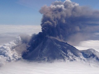
Image courtesy of NASA Goddard Photo and Video
Monitoring a Volcano With GPS Tracking
We think of GPS tracking devices as monitoring things that move from one place to another—things like cars, bicycles, airplanes, and even people. But when an Iceland volcano named Grímsvötn erupted in 2011, scientist used GPS tracking to monitor the ground movement caused by volcanic activity. Knowing that the volcano was preparing for an eruption, scientist placed a tracking device on its side. The device began measuring significant ground movements about an hour before the actual eruption occurred. While more testing needs to take place, scientists hope that this is just the first of many steps in better understanding the activity of a volcano and being able to predict when the next eruption will take place.
Sigrún Hreinsdóttir, University of Iceland geophysicist and author of a journal article about the Grímsvötn eruption, hopes to use the data gathered from GPS tracking devices to determine not only when a volcano is getting ready to erupt, but also exactly when that eruption will be and how high the ash plume will reach. He posits that the GPS data recording the ground movement around the volcano can be used to calculate pressure changes in the volcano’s magma chamber underground. This information can in turn help predict how high the ash plume will be.
How GPS Data About Volcanoes Can Save Lives
The science surrounding volcanoes is fascinating, but more importantly, it can make the difference between life and death in a highly dangerous situation. Here are three ways the increased accuracy afforded by GPS tracking data can make a difference in the event of a volcanic eruption:
- More warning for those living nearby—Volcanoes can still claim lives if people aren’t warned in time. GPS tracking can provide earlier warning of imminent eruption, giving nearby residents a chance to evacuate.
- Better knowledge of ash plume activity—Volcanic ash plumes can cause planes to be grounded hundreds or thousands of miles away. Having an estimate of the size of the ash plume can give air traffic controllers the information they need to make better decisions about when and where to ground flights.
- Estimates about the size of the eruption—Knowing the estimated size of the eruption itself can facilitate better decisions about who needs to be evacuated and what additional steps need to be taken.
When it comes to a volcanic eruption, those affected most are the people who live nearby and must worry about homes, crops, and property. With more detailed information, these people could not only have enough warning to escape the path of the eruption, but also to protect some of the things they care about.
Limitations to GPS Tracking Study of Volcanoes
With so much potential for better information, shouldn’t GPS tracking devices be able to predict each and every volcanic eruption? Yes and no. There are still some limitations to scientists’ ability to study GSP data about volcanoes:
| Volcano locations | Some volcanoes, like Grímsvötn, are mostly covered in ice. Because ice sheets shift regularly, GPS tracking data about the volcano itself isn’t always accurate |
| Early stages of study | Studying volcanoes using GPS tracking devices is a relatively new approach. While many theories have been formed about how that data can be used, its accuracy hasn’t been clearly demonstrated yet |
Hreinsdóttir hopes to gain additional support for his approach as he studies future volcanic eruptions. The more times he can accurately predict what the volcano will do based on the data he’s gathered using GPS tracking devices, the more he can fine tune his methods to get the best possible information.
Hreinsdóttir’s approach seeks to answer the two most basic questions about every volcanic eruption: When will it happen and how big will it be? Seismic instruments have given scientists some approximate answers to date, but Hreinsdóttir hopes that the GPS tracking data will revolutionize the study of volcanoes by providing much more detailed information about the size of the eruption and resulting ash plume as well as the ground movement.
Although we often think about the most devastating volcanic eruptions as having taken place hundreds or thousands of years ago, people still die in eruptions today. Perhaps with the help of GPS tracking, those deaths can be eliminated.
GPS Tracking In the Shadow of the Volcano

No comments:
Post a Comment